Adrienne and I made the drive up to Saint-Donat, QC starting about 3:30 on Friday night so we could make it up for registration which closed at 9 pm. We weren't nearly as organized for this race as we were for the Bitter Pill, since each of us were coming off busy work weeks. Thanks to Adrienne for taking a little extra time off on Friday we had everything we needed even if we hadn't organized our packs.
 After the race check in we got together with the other team that I knew up there from Dealer.com and went out for a couple drinks. After that both of us were exhausted and we needed to get some Zs.
Here's an overview of the course that I put together.
In the morning we had to get to the place we registered by 8 am with a couple of detours on the way to drop off our bikes and our pfds and paddles. When we got to the registration place again we got our maps and had about 1/2 hour to look them over. Then we got to listen to about 30 minutes of French, followed by about 10 minutes of quick English instructions. There was only one part that was confusing to me, but I thought I got it. I'll admit I was disappointed since I was hoping for some nav challenges, but other than a 200 meter trek off trail (which they apologized for and as it turned out a trail was available) it was all on trail. As we'll see, though it might have been for the best that they didn't have any serious nav challenges (though I'd like to think it would've woken me up...).
When everyone was ready they load us into a couple buses and drove us to downtown Saint-Donat. We had a bit of time to wait and the temperature was a little on the chilly side, but at 9:30 we were given the green light and everyone started moving.
 We had about a 1/2 mile jog to where our bikes were. We quickly got on our bikes and got on the trail. Unfortunately, Adrienne's bike was again not quite tuned up. After running into a couple issues we switched so I could check it out (not that I could do much for it, but I also was determined for her to not have two crappy mountain biking experiences in a row :) ). As it turns out the front derailleur wouldn't allow it into third and the rear one had trouble going from fifth to fourth. On top of that the tires created so much drag that the bike was horrible going up hills and through sand. Fun.
The bike to TR2 was on an easy trail, unfortunately during this trip we realized that we had no idea what the scale of the map was. (Afterwards we learned - though I think it was relearned in my case - that there are two standard scales and the maps we were using were 1:50.) Additionally, the area that I didn't understand from the directions got us. They told us Chemine Wall would be going down hill in the opposite direction and we'd see a blue trail marker for the cycling trail. For some reason I took opposite to mean it would be on the other side of a four way intersection. So when we came to a three way intersection with the road to the right kindof doubling back and going down hill it didn't make me think we were there. It didn't help that of the two teams we saw at that intersection one went each way. We discovered our mistake when we saw a sign for for Route 329 back 1.8 km the way we came.
The biking took us a lot longer than I would've liked, but neither of us are especially strong at that. Regardless around 11:30 we were making our way into the woods for what looked like a quick three checkpoints. Sadly my brain had turned off. Every intersection I was guessing where we were and forgetting to confirm what was around us and what the terrain looked like. Part of that was due to us not knowing the scale, but a lot of it was me just not looking around and confirm where a freekin' lake was. Or where a hill should be. Heck, even what direction we're going (though I did do a little of that towards the end). Needless to say this did not make for an enjoyable hike in the woods. We ran into a team a couple times that was making similar mistakes, but at least one of them was able to piece things together and get us back on the right track. We got all three checkpoints and made it back out without any more issues.
We came off the mountain just before 2 pm and not in a great state of mind. I was severaly disappointed with myself for messing up the navigation so much. After discussing our options we decided that we'd just assume not do the technical mountain biking, but just get on with the kayaking. So we stayed on the road around to the TR3. (After the race we heard that a number of teams had trouble with CP4. So given my navigation issues it made me even happy that we made that choice.)
So we dropped our bikes off at TR3 and made the short walk to the kayaks. I'll confess - Adrienne was hoping for a jog, but my right knee was bugging me almost all day and I wasn't up for it. We dropped our packs, put on our PFDs, and grabbed paddles and an inflatable kayak. Nice thing about these kayaks - easy to carry. Not so nice thing - they can deflate.
 (After the race a team told us there's was losing air on one side and by the end of the paddle they had to lean to the right to stay afloat.) The paddle was a nice change and we didn't have any issues with it other than a cloud blocking the sun from us for most of the time.
 We left our kayaks, paddles, and PDFs, snagged up our packs and made our way back up to where we left the bikes. From there we had to go up the ski slope which wasn't too bad - though I was certainly not charging up it. At CP9 they a two rope bridges setup across the slope. We each went across which wasn't too difficult (as long as I wasn't trying to catch up to Adrienne). My arms were sore for the next couple days, but I only noticed it when I held them above my head.
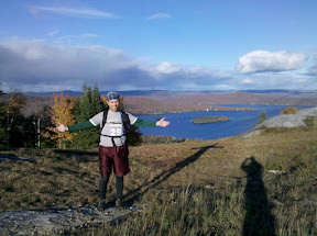
Then we made it to the top - found the final checkpoint, took a couple pictures
 , and traipsed back down the hill. Even found enough energy at the end to run to the finish - it helps that they have the podium with the loud speaker and I was able to understand enough French to know they were talking about us.
 Somehow we ended up 23 out of 33 and 2 in our division of 6. The scenary was nice and that does seem to be there focus, but I was disappointed by the lack of a technical navigation section. So in the end, while we had a good time and met with a challenge I don't think I'll make the trip back up for more of their races.
No comments:
Post a Comment